
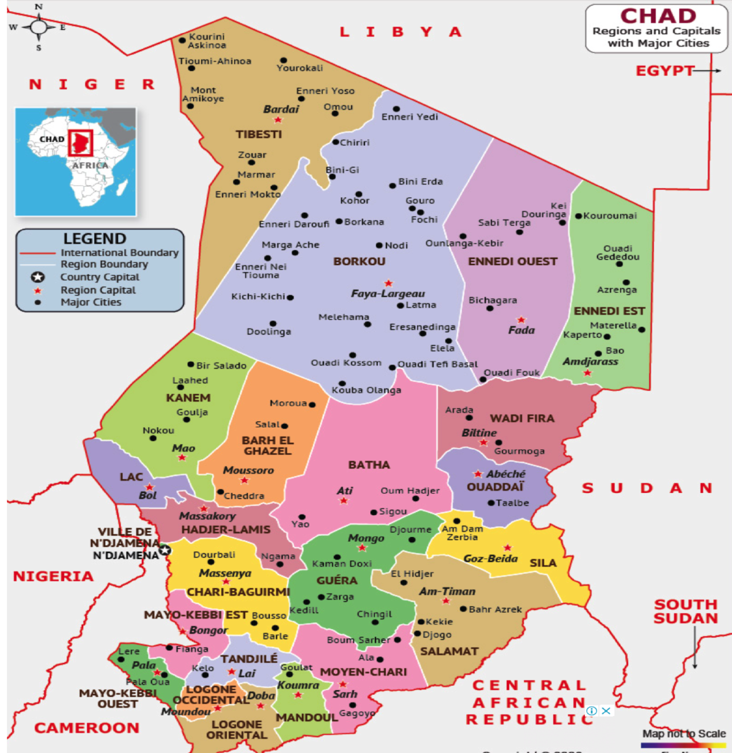
Chad, independent since 1960, was first divided into 14 prefectures, then into 28 around 1999. Since 2008, it has been divided into 23 regions comprising 107 departments. On August 10, 2018, Ordinance 038/PR/2018 on the creation of Administrative Units and Autonomous Communities was issued to redefine the regions into provinces. The former regions become provinces subdivided into departments and communes. The provinces of Chad are : Bahr el Ghazel, Batha, Borkou, Chari Baguirmi, Ennedi Est, Ennedi Ouest, Guera, Hadjer Lamis, Kanem, Lac, Logone Occidental, Logone Oriental, Mandoul, Mayo Kebbi Est, Mayo Kebbi Ouest, Moyen Chari, Ouaddai, Salamat, Dar Sila, Tandjile, Tibesti, Wadi Fira, N’Djamena. The provincial map is as follows:
Detailed presentation of the new Provinces
Bahr el Ghazel Province: Its capital is Moussoro, and it is subdivided into the following departments: Bahr el Ghazel Nord, Bahr El Ghazel Sud, Bahr el Ghazel Ouest and Kleta. It covers an area of 50,860 square kilometers. The province of Bahr el Ghazel is geographically located in the west, and its main economic resource is based on livestock farming. The Barh El Gazal is an area of great prairie and the world’s largest desert along with the Sahara.
Province of Batha : Batha has Ati as its capital and is subdivided into six departments: Batha Est, Batha Ouest, Fitri, Ouadi Rime, Assinet and Djombo Djedid. With its essentially flat terrain, the Batha province has a Sahelian climate in the south and a semi-desert Saharan climate in the north. Rainfall is unpredictable, insufficient and often poorly distributed in space and time. As a result, the region is ecologically heterogeneous, with predominantly wooded vegetation and a temporary hydrographic network that flows into Lake Fitri, its only permanent reservoir and watercourse. It has a cosmopolitan population, the majority of whom live in rural areas. The Batha is a livestock-raising area par excellence, with a large herd of cattle.
Borkou Province: Borkou province is subdivided into four departments (Borkou, Borkou Yala, Kouba and Emi Koussi), with Faya Largeau as its capital. Occupying the northern part of Chad, Borkou is bounded to the west, from north to south by the Precambrian basement, the volcanic formations of Tarsos Emissi, Aozi, Emi Koussi and the sandstone foothills of Tibesti; to the east by the Ennedi massif; to the north by the Erdis; to the south by the Angama and Taimanga slopes and the Djourab Erg.
The Borkou constitutes an original depressed zone between the ancient Tibesti massif (3400m), its Paleozoic aureole and the Ennedi. The Borkou region is one of Chad’s unexploited mineral reserves and, with its massifs and dunes, one of the most excellent tourist areas in the country.
Chari Baguirmi Province: With Massenya as its capital and Baguirmi, Chari, Loug chari and Dourbali as its departments, Chari Baguirmi is located in the west of the country, on the left bank of the chari river. Its ethnic-linguistic groups are the Boulala, Kotoko, Peuhl, Barma, Kanouri, Mousgoum, Massa and Ngambaye. The fauna is diverse in this region, with all varieties of gazelle, antelope and elephant. For some years now, oil has been gushing out of Koutalwa Ronnier and MimosaL Oil royalties contribute to local development and the fight against poverty for the people of this oil-producing province.
Province of Ennedi Est: Its departments are: Amdjarass, Wadi Hawar, Itou, Bao, Mourdi. Its capital is Amdjarass. The province is located in the northeast of the country and borders Sudan and Libya. It is geographically part of the Sahara Desert. Its ethnic-linguistic groups are the Dazaga, Toubou and Zaghawa. This region of Chad is also ideal for tourism.
Pictorial illustration of the massifs and dunes of the Eastern Ennedi, as well as a representation of its traditionally-built houses.
Ennedi Ouest province: The Ennedi Ouest region has Fada as its capital and the following departments: Fada, Mourtcha and Lake Ounianga. It is located in the north-west of the country and borders Libya. Its main ethnic-linguistic groups are the Tedaga, Dazaga, Toubou and Zaghawa.
Guéra Province: Its capital is Mongo, and its departments are: Barh Signaka, Guéra, Abtouyour, Mangalmé and Garada. It is made up of granite massifs rising to 1,800 m, intersected by numerous dolerite dykes. Located in the south-central part of the country, the province receives 744mm of rainfall a year and includes several vegetation zones, making it one of the most important agricultural areas (peanuts and cotton). Its ethnic-linguistic groups are Hadjarai and Arab. Thanks to its mountain ranges and proximity to the Zakouma Park, the Guéra is a prime tourist destination.
The province of Hadjer-Lamis: Located in the west of the country and bordering Cameroon, its capital is Massakory and its departments are Dababa, Dagana, Haraze Al Biar and Ngoura. Its main ethnic-linguistic groups are the Medego, the Boulala, the Kouka, the Goranes and the Arabs. Its economy is essentially based on agricultural and pastoral production.
Province of Kanem: With Mao as its capital and Nord Kanem, Kanem and Sud Kanem as its departments, the Kanem region is located in the west of the country and borders Niger. Its main ethnic and linguistic groups are the Daza, Kanembou, Arab and Touareg. Livestock farming is the province’s main economic activity. Kanem is an oasis zone with large palm groves.
Lac Province: Its capital is Bol and its departments are : Fouli, Kaya, Mamdi, Wayi, Doum Doum and Kouloukimé. It is located in the west of the country and borders Niger, Nigeria and Cameroon. Its ethnic-linguistic groups are the Kanembou, the Yedina or Boudouma and the Haoussa. The region is considered to be a hotbed of Boko Haram clashes, but also home to refugees, mainly from Nigeria. Thanks to its fish resources, Lake Chad covers the food fish needs of Chad and other riparian countries. This province has the largest polder reserve in the world, where corn, wheat, spirulina (seaweed), vegetables and fruit trees are grown.
The Province of Logone Occidental: with Moundou as its capital and the departments of Dodjé, Lac Wey, Ngourkosso and Guéni: Dodjé, Lac Wey, Ngourkosso and Guéni, Logone Occidental is located in the south of the country and borders Cameroon. Its main ethnic-linguistic group is the Ngambayes, and its economy is based on food crops and cotton growing. An economic zone, Logone Occidental is home to industries and exports oil from its subsoil at two sites, Mangara and Ngourkosso.
Logone Oriental Province: Its capital is Doba, and its departments include Nya Pendé, Monts de Lam, Nya, Kouh-Est and Kouh-Ouest. Located in the south of the country, it borders the Central African Republic and Cameroon, and is home to the Ngambayes, Gor, Mboum, Goulaye and Mongo ethnic and linguistic groups. Its economy is based on food crops (cassava, millet and sorghum) and cash crops (cotton and groundnuts). A large oil field has been exploited since 1988 to the south-west of Doba, and exported via the 1070km pipeline linking the coast of Cameroon to Kribi, which has been in service since 2003. The exploitation of this reserve is the biggest contributor to the country’s public budget. However, the royalties of 5% of oil resources paid by the central government do not contribute enough to the development of the producing area.
Mandoul Province: Its capital is Koumra and its departments are : Barh Sara, Mandoul occidental, Mandoul oriental, Goundi and Taralnass. The province is located in the south of the country and borders on the Central African Republic. Its main ethnic-linguistic groups are the Sara (Madjingaye), Mbaye, Goulaye, Nar, Daye and Toumak of Goundi. Its economy is based on food crops and cotton.
Province of Mayo-Kebbi Est: This province has Bongor as its capital and the following departments: Mayo boneye, Kabbia, Mont Illi and Mayo lémié. Located in the south-west of the country, it borders Cameroon and its ethnic-linguistic group is made up mainly of the Moussey, Massa, Toupouri, Marba, Kéra, Mousgoum and Kim. A major rice-growing area, its economy is based on agriculture and fishing.
Mayo-Kebbi Ouest Province: Located in the south-west of the country and bordering Cameroon, Mayo-Kebbi Ouest Province has Pala as its capital, and its departments are Lac Léré, Mayo-Dallah, Mayo-Binder, El-Ouaya and Gagal. Its ethnic-linguistic groups are the Moundang, Zimés, Peuhls, Ngambayes and Moussey, and its economy is based on food crops, livestock, fishing and cotton growing.
Province of Moyen Chari: Its capital is Sarh, and its departments are: Barh Kôh, Grande Sido, Lac Iro and Korbol: Barh Kôh, Grande Sido, Lac Iro and Korbol. Located in the south of the country, this region borders the Central African Republic and its ethnic-linguistic groups include the Sar, Daye, Ngama, Sara-Kaba and Tounia. Its economy is based on food crops, livestock, fishing, cotton and sugar cane. The Moyen Chari province is home to 3 industrial chains: SONASUT, the cotton ginning plant and the Sarh textile factory.
Ouaddaï Province: Ouaddaï is one of 23 provinces whose capital is Abéché, with the departments of Djourouf Al Ahmar, Assoungha, Ouara and Abougoudam. This province is located in the east of the country and borders Sudan. Its main ethnic-linguistic groups are the Maba, the Mimis, the Mararites, the Massalites, the Assoongor, the Mesmedjé, the Aboucharib, the Kinin or Touaregs, the Tamas, the Zaghawa and the Chad Arabs. Its economy is essentially based on trade, crafts, livestock and agriculture.
Salamat Province: Its capital is Am Timan and its departments are : Aboudeia, Barh Azoum and Haraze-Mangueigne. Located in the south-west of the country, it borders the Central African Republic and Sudan, and is home to the Salamat Arabs, Hemat Arabs, Rachid Arabs, Kolomat Arabs, Kibets, Dagals, Iyalnas, Sara Kaba and Torams ethnic-linguistic groups. Like Lake Chad, the Salamat province is an area of vast, rich plains, and its soil can cover all the cereal needs of the Chadian people, the main source of food.
Its economy is based on food crops, livestock, fishing and cotton growing. An international tourism zone par excellence, the Salamat Province boasts the largest wildlife park and reserve south of the Sahara. However, the absence of a dual carriageway during the rainy season means that the region is cut off from the national economy.
Dar Sila Province: with Goz Beida as its provincial capital and the following departments: Abdi, Kimiti, Tissi, Adé and Koukou-Andarana. Dar Sila is located in south-western Chad, bordering Sudan and the Central African Republic, and is a host area for refugees from Sudan. Its ethnic-linguistic groups are the Birgit, Dar Sila Daju, Fongoro, Fur, Kajakse, Karanga, Kibet, Kujarge, Runga and Sinyar. Its economy is based on trade and food crops.
Tandjilé Province: The province’s capital is Laï and its departments include Tandjilé Est, Tandjilé Ouest, Tandjilé Centre, Manga and Manbagué. Tandjilé Province is located in the south of the country and covers several ethnic-linguistic groups, namely the Marba, Lélé, Zimés, Nangtchéré, Ngambayes and Gabri. Its economy is essentially based on livestock breeding and the cultivation of rice and sorghum.
Tibesti Province: Its capital is Bardai, and its departments are Bardai, Aouzou, Zouar and Wour. Tibesti, whose name means “place where mountain dwellers live”, is the domain of the Toubous. Its economy is based on cereal crops, tourism and livestock. The massif and its surroundings contain significant quantities of uranium, tin, tungsten, niobium, tantalum, beryllium, lead, zinc, copper, platinum, nickel, gold, diamonds, emeralds and natron. There’s also the Soborom geothermal field, which means “healing water”; this lake is renowned for its medicinal virtues (a pool with water at 42 degrees is said to cure dermatitis and rheumatism after a stay of several days).
Province de Wadi Fira : avec Biltine comme capitale, la province de Wadi Fira comprend les départements suivants : Biltine, Dar Tama, Iriba, Mégri, Al Biher et Dar-Alfawakih, et est principalement peuplée de Zaghawa, Arabes, Mimi, Tama et Ouaddaï. Il est situé à l’est du pays et fait frontière avec le Soudan. C’est une zone agro-pastorale et de transhumance.
La province de N’Djamena, capitale du Tchad : Capitale N’Djamena, anciennement Fort Lamy. En tant que capitale, cette province est composée de 10 communes d’arrondissement. N’Djamena, qui signifie étymologiquement “nous nous reposons” en arabe, est la capitale administrative et politique et la plus grande ville du Tchad. Elle est située au centre-ouest du pays, au confluent du Chari et du Logone, sur la rive droite du Chari. De par son statut, N’Djamena est le siège des institutions politiques et républicaines du pays. N’Djamena est une ville à propension démographique, avec une population cosmopolite de plus d’un million d’habitants.


